Install now and digitize the street space!
Smartphone-based retrofit solution for creating a digital twin
The Eidos-Road-Glancr-App from Fraunhofer FOKUS offers a new, scalable solution for recording traffic-related objects in public spaces using standard Android smartphones.
Using artificial intelligence directly on the device, known as edge AI, traffic data is processed in compliance with data protection regulations and analyzed in real time. The solution was developed specifically for use in existing vehicle fleets, such as taxis, public transportation, garbage collection, and delivery services, already on the road. The app thus offers an economical alternative to specialized recording vehicles and targeted driving routes.
Functionality and technology
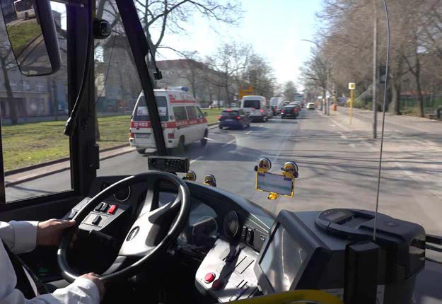
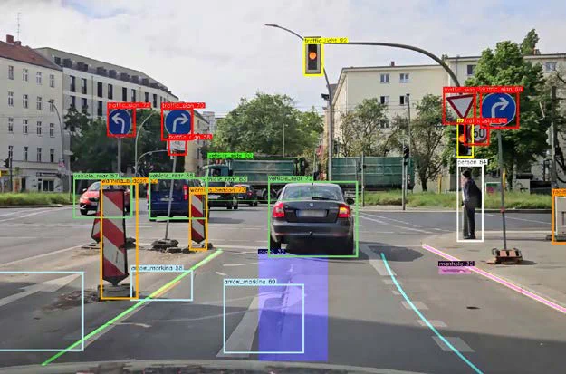
A smartphone equipped with the app is mounted in the windshield of a vehicle facing the road. While driving, the system uses AI models to analyze camera images continuously directly on the device. The app recognizes a wide range of traffic-related objects: pedestrians, cyclists, scooters, and vehicles, traffic lights, traffic signs, road markings, barriers, etc.
Only abstract information about recognized objects, such as the object type and its relative position to the camera, is transmitted to a secure server at Fraunhofer FOKUS via mobile communications or Wi-Fi and processed further. Camera images or videos are not stored or transmitted, so no personal data, such as faces or license plates, is recorded. Individual image sections, such as traffic signs, are transmitted only in exceptional cases to improve recognition quality.
Data protection compliance as a system principle
The entire recognition and evaluation process is designed to be fully GDPR-compliant. Thanks to the local real-time processing of image data on the device and the targeted reduction of transmitted information to the meta-level, the Eidos Road Glancr app is also data protection-compliant in terms of future citizen participation.
Scalability, quality, and system robustness
Unlike dedicated measurement vehicles, the Eidos Road Glancr app does not rely on maximum precision in individual measurements, but rather on the statistical reliability of large amounts of data. The frequent trips and comprehensive monitoring enable robust change detection and continuous consolidation of traffic space knowledge. The system automatically compares previously recorded situations with new observations, detects deviations, and continuously calibrates itself.
In contrast to specialized measurement vehicles or dedicated sensor platforms, the app offers a low-threshold, cost-efficient, and scalable solution. Each additional smartphone increases the database. In this way, the digital representation of the road space can be continuously improved. The technical barrier to entry is minimal: all that is needed to use the app is a smartphone with the app and a standardised holder in the vehicle. No modifications to the vehicle hardware or special training are necessary.
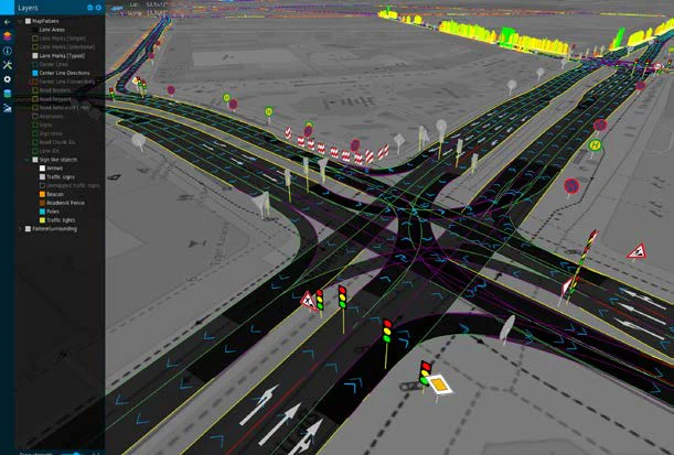
Digital twin and backend integration
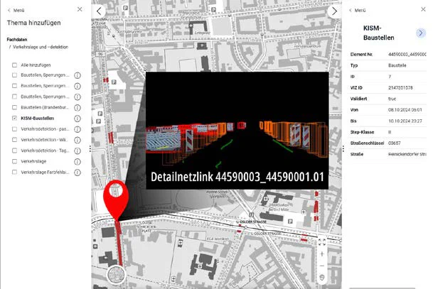
Fraunhofer FOKUS has many years of experience in processing large amounts of data. Using specially developed backend tools, raw sensor data is automatically analyzed, spatially and temporally localized, and transferred to scalable databases. This creates a precise, dynamic image of the urban space – the digital twin. Visualizations and interfaces make this data immediately usable for cities.
A concrete example of this is the Digital Platform for Urban Transportation (Digitale Plattform Stadtverkehr/DPS), which allows data generated by the app to be used by the Berlin Senate Department for Mobility, Transportation, Climate Protection, and the Environment (SenMVKU)

Since 2020, the app has been successfully tested in collaboration with the Berlin Senate. In partnership with the Berliner Verkehrsbetriebe (BVG) and various transport service providers, 40 vehicles have been permanently equipped, and more than 1.5 billion objects are recorded annually on 400,000 kilometers of roads – in a wide variety of environments ranging from urban areas to interurban roads and urban motorways.
Future developments
The system is being expanded to include voluntary citizen participation via a publicly accessible app. The aim is to democratize data collection further and, with the help of citizens, make the city‘s digital twin even more comprehensive and up to date.
Target groups
The Eidos Road Glancr app supports both municipalities and cities in fulfilling their sovereign, traffic-related tasks, as well as service providers who use the data to optimize their processes and business models:
- Cities, municipalities: The app offers data protection-compliant and comprehensive recording of the road space for digital twins and automated detection of changes (e.g., traffic signs, construction sites).
- Road operators: The app enables ongoing monitoring of road conditions and early detection of damage and hazardous areas through cost-effective, scalable monitoring without the use of special vehicles.
- Fleet operators: The app offers fleet operators the option of upgrading their vehicles to mobile sensor nodes.
- The traffic data generated in this way (XFCD) is marketable and enables the development of new sources of revenue.